


का विवरण Hiking Slovakia - Tourist Map
Hiking app covering the area of Slovakia. A must-have for every hiker.
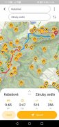
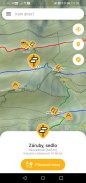
• All marked hiking trails and junctions
• Large database of peaks, viewpoints, picnic or camping sites, castles, caves, water sources, shelters or accomodations
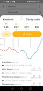
• Elevation and contour maps with scale
• Ability to download maps to phone and use them offline
• Indication of current location
• The distance to any point
• Search among the junctions and other points of interest
• Augmented reality for better orientation in the terrain
• Compass
Warning: If you like being lost, love adrenaline and survival, don't get this app... ;-)
Required permissions: location (see the current position on map), Internet access (maps), access to the SD card (locally stored maps), camera (augmented reality)
The application uses freely available data from projects freemap.sk and openstreetmap.org
पर्वतारोहण एप्लिकेशन स्लोवाकिया के क्षेत्र को कवर। हर यात्री के लिए एक होना चाहिए।
• सभी चिह्नित लंबी पैदल यात्रा ट्रेल्स और जंक्शनों
• चोटियों, दृष्टिकोण, पिकनिक या शिविर स्थलों, महल, गुफाओं, पानी के स्रोतों, आश्रयों या रहने की जगह के बड़े डाटाबेस
• पैमाने के साथ ऊंचाई और समोच्च नक्शे
• फोन के नक्शे डाउनलोड करने और उन्हें ऑफ़लाइन उपयोग करने की क्षमता
• वर्तमान स्थान का संकेत
• किसी भी मुद्दे पर दूरी
• जंक्शनों और हित के अन्य बिंदुओं के बीच खोजें
• इलाके में बेहतर उन्मुखीकरण के लिए संवर्धित वास्तविकता
• दिशा सूचक यंत्र
चेतावनी: अगर आप खो दिया जा रहा पसंद है, एड्रेनालाईन और अस्तित्व से प्यार है, इस एप्लिकेशन को नहीं मिलता है ... ;-)
आवश्यक अनुमति: स्थान (मानचित्र पर मौजूदा स्थिति को देखें), इंटरनेट एक्सेस (नक्शे), एसडी कार्ड (स्थानीय रूप से संग्रहीत नक्शे) के लिए उपयोग, कैमरा (संवर्धित वास्तविकता)
आवेदन परियोजनाओं freemap.sk और openstreetmap.org से स्वतंत्र रूप से उपलब्ध डेटा का उपयोग करता है
Hiking Slovakia - Tourist Map - Version 3.0.10
(26-03-2022)
Hiking Slovakia - Tourist Map - एपीके जानकारी
एपीके संस्करण: 3.0.10पैकेज: sk.archae.hiking.androidApps in the same category
You may also like...


